How one of the UK's leading fit-out specialists replaced days of traditional surveying with a 10-minute handheld LiDAR scan, and cut survey and drawing time by 800%.
Construction Surveying • Handheld LiDAR • Scan-to-BIM
~80%
reduction in survey and drawing time
10 mins
to scan an 8,434 ft² office floor
<2 hrs
from scan to complete Revit model
When office fit-out company BW sent their surveying team to a London office for a leading global private bank, they weren’t planning to change the way they work. They were planning a fit-out survey.
What happened instead was that an 8,434 ft² floor was fully scanned in 10 minutes. A complete Revit model, with point cloud data, photographic reference, and coordinated 2D plans, was ready before lunch. A process that previously took days was finished in a single morning.
This case study provides a close look at how that workflow actually works, and why BW now uses NavLive’s handheld LiDAR scanner as standard across their UK and international projects.
“With NavLive, we no longer need repeated site visits to verify details as the scanner generates both a precise point cloud model along with accompanying reference images. This has completely transformed the way we survey, saving countless hours of work.”
BW is one of the UK and Europe’s leading workplace fit-out specialists, delivering environments for some of the world’s largest organisations. Innovation is a core part of how they operate. Their teams are consistently early adopters of technology that improves accuracy, speed, and cross-disciplinary collaboration.
That said, even BW approached NavLive with some initial scepticism. Could a handheld scanner, something a single person walks through a space with, truly match the accuracy of a traditional survey team? And could it do so quickly enough to change established workflows on live, occupied projects?
The starting question
Can a handheld LiDAR scanner replace a full survey team for fit-out documentation, without sacrificing the accuracy that design and M&E teams depend on?
The Challenge: Days of Work, Multiple Visits, Delayed Design
Before adopting NavLive, BW’s design and architecture teams relied on traditional survey methods. Measuring by hand, using total stations, or working with static tripod laser scanners that require setup and re-setup in every room.
The result was a slow, labour-intensive process. Capturing accurate as-built data for a complex multi-room office environment could take days. Design work was frequently delayed waiting for a survey (which they often did) it meant another site visit, another round of scheduling, and another delay.
For a fit-out business operating at pace across multiple simultaneous projects, this was a significant operational drag. The problem wasn’t skill or effort; it was the fundamental nature of the tools.
The Solution: One Person, One Device, One Visit
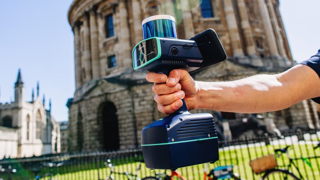
The NavLive Radius scanner combines LiDAR sensors, three high-resolution cameras, and an on-board NVIDIA Jetson Orin AI processor into a single handheld unit. There’s no tripod setup. No additional equipment. No separate processing step back at the office.
As the user walks through a building, the device uses SLAM (Simultaneous Localisation and Mapping) developed from PhD research in robotics at the University of Oxford, to continuously calculate its position and build a precise 3D model of the space in real time. By the time the surveyor walks back out, the scan is already processing.
BW’s New Measuring Workflow
1
On site — 10 minutes
Walk and scan
One BW technical designer arrives on site with the NavLive scanner. No setup is required. They walk through each room of the floor at a normal pace, the scanner automatically capturing point cloud data, spatial geometry, and high-resolution reference photos simultaneously.
2
Automatic — during scan
Real-time processing on device
On-board AI processes the scan as it happens. Floor plans, elevations, and 3D point cloud data are generated in real time — not uploaded for cloud processing hours later. The designer can confirm complete coverage before leaving the building.
3
Automatic — on upload
Instant sync to NavLive Portal
Scan data uploads directly to the NavLive cloud portal. The full team — designers, M&E coordinators, project managers — can access the point cloud, floor plans, and reference photos immediately, from any device, while the surveyor is still travelling back.
4
Back at the office — under 2 hours total
Revit model ready
BW’s designers import the point cloud data directly into Autodesk Revit. NavLive is an Autodesk Authorized Developer, with native compatibility for Revit, AutoCAD, Archicad, and SketchUp. The E57 or LAS point cloud, combined with photographic reference, gives designers everything needed to build a fully coordinated as-built model.
The Results: 80% Faster, With Better Data
Since adopting NavLive, BW has cut survey and drawing time by around 80%. Spaces that previously took days to measure and model are now captured in under an hour on site, with fully coordinated 3D and 2D outputs available the same day.
Critically, the quality of the output is higher than traditional methods, not lower. By capturing both dense point cloud data and photographic context in a single pass, NavLive gives designers a unified, verifiable record of every project. There’s no ambiguity about room heights, service routes, or structural positions. Every stakeholder works from the same verified information.
The key outcome
A single NavLive scan replaces multiple site visits, eliminates coordination lag between design and M&E teams, and produces better documentation than traditional methods, all within a fraction of the time.
The improvement extends to international projects too. For fit-out work outside the UK, a single well-documented site visit now captures everything, removing the cost and delay of repeat travel for missing measurements or verification queries.
What NavLive Means for the Wider BW Team
The impact of NavLive at BW goes beyond the surveyor. Because all data is captured in one visit and shared instantly via the portal, design teams get earlier access to verified site information. M&E coordination happens from the same source of truth. Errors that arise from working from different survey versions, a persistent problem in traditional workflows, are effectively eliminated.
For BW, NavLive has not just improved survey efficiency. It has changed the baseline for what “as-built” documentation means in modern workplace design. The standard is now: everything captured in one visit, shared in real time, ready for design that same day.
Frequently Asked Questions
How long does it take to scan a building floor with NavLive?
Typical scan speeds depend on the size and complexity of the space, but BW scanned an 8,434 ft² London office floor in 10 minutes. Most single-floor commercial spaces can be completed in under 30 minutes.
Can NavLive produce a Revit model from a scan?
NavLive exports E57 and LAS point cloud files that import directly into Autodesk Revit, AutoCAD, Archicad, and SketchUp. NavLive is an Autodesk Authorized Developer. BW produced a complete Revit model within two hours of completing a 10-minute site scan.
How accurate is a handheld SLAM scanner compared to traditional survey methods?
NavLive’s SLAM technology, developed from robotics research at the University of Oxford, produces RICS-grade 1:100 surveys. The combination of point cloud data and photographic reference gives design teams a more complete and verifiable record than hand measurements alone.
Does NavLive work in occupied office buildings?
Yes. NavLive requires no tripod setup and no disruption to the space. BW regularly uses it in active workplaces, walking through with the handheld device while normal office activity continues around them.
What files does NavLive produce?
NavLive exports point clouds in E57 and LAS format, 2D drawings in DWG, DXF, and PDF, and reference photography in JPG. All outputs are available through the NavLive Portal immediately after a scan completes.
How does NavLive compare to FARO, Leica, or NavVis scanners?
Where tripod-based scanners like FARO Focus and Leica RTC360 require setup in every position, NavLive is fully mobile – one continuous walk captures the whole space. NavVis offers wearable mobile scanning, but at a significantly higher cost and with more complex deployment. NavLive is designed specifically to be operated by a single person with no specialist training, making it suited to fit-out and construction teams who need to scan regularly without a dedicated survey resource. See our full comparison →
See the NavLive Workflow on Your Own Project
We'll come to your office or live site, scan a floor, and share the point cloud, floor plan, and photo output, all in a single 30-minute demonstration.
Sign Up for Construction Tech Updates
Join the NavLive newsletter and be the first to know what’s shaping the future of digital construction.
Schedule your NavLive demo
In this initial 15-minute call, we'll:
Gather some quick info about your current surveying workflows.
Answer any questions you have about NavLive.
Schedule an in-person site visit to demo the NavLive scanner at your office.