Why Universities Need NavLive

Universities manage complex estates. Lecture halls, labs, offices, student housing, heritage buildings, and maintenance facilities. Historically, much of this is tracked through spreadsheets, surveys, architectural drawings, and legacy BIM systems that rarely stay up to date.
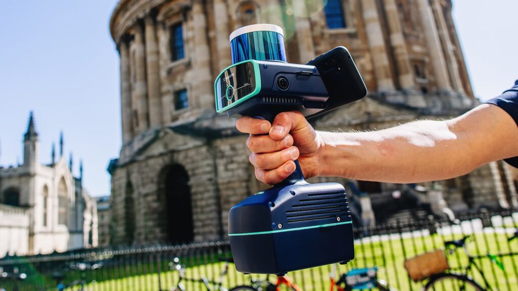
But the NavLive Scanner gives universities a fast, reliable way to build and maintain a living, digital twin of their entire campus, down to every room, corridor, service shaft, and staircase.
With SLAM (Simultaneous Localisation and Mapping) built into a handheld unit, your estates teams or external contractors can walk through the building capturing 2D floor plans, 3D point clouds, and textured panoramas, all in minutes.
How Universities Use NavLive
Universities can use NavLive to create a complete, living digital record of their estate, capturing everything from lecture theatres to listed buildings.
- Establish a baseline scan of every campus building.
- Keep it current by capturing each renovation, extension, or reconfiguration.
- Maintain a digital repository that links geometry, metadata, and spatial relationships across your entire university estate.
Because it’s handheld, portable, and SLAM-based, you don’t need line-of-sight scanning or elaborate setups. You can capture tight interiors, even service tunnels or historic nooks, with ease.
Rooted in Oxford Robotics Research
NavLive grew out of cutting-edge research in the robotics & perception labs at the University of Oxford. Our founding team harnessed advances in lightweight SLAM, spatial computing, and autonomous mapping to make what once lived in robotics labs accessible to real-world built environments.
We carried that academic rigor into every product decision, ensuring calibration accuracy, robust error correction, and repeatable workflows that satisfy the demands of institutional users.
In short, the NavLive Scanner isn’t a consumer gadget. It’s a tool born from university-level science, built for institutional scale.
How NavLive Supports Regulatory Compliance & University Obligations
1. Building Safety Act & the “Golden Thread of Information”
The Building Safety Act 2022 embeds a requirement for “golden thread” information, a digital, trustworthy record of every building’s lifecycle.
NavLive helps fulfil that obligation by versioning and timestamping every scan, creating a full audit trail of spatial change across rooms, corridors, and services.
Each dataset links building assets directly to their geometry, giving estates teams a verifiable, digital chain of evidence that stands up to audit or inspection.
—–
2. Fixed Asset Registers & Institutional Audit Requirements
Universities are required to keep accurate fixed asset registers, but most lack spatial depth. NavLive bridges that gap by mapping every building, space, and sub-asset directly to its financial record.
Estates teams can link geometry to maintenance schedules, condition surveys, and depreciation data, turning a static ledger into a spatially intelligent asset management system that reflects the real state of the campus.
—–
3. Supporting Health, Safety & Fire Regulation Oversight
From evacuation planning to inspection records, NavLive helps universities maintain up-to-date, verifiable spatial data for safety and compliance. Estates teams can instantly compare scans over time to detect layout changes, ensuring every safety plan reflects the real building, not an outdated drawing.
NavLive Use Cases on Campus
| Use Case | Problem Without NavLive | With NavLive |
|---|---|---|
| Baseline Campus Survey | Drawing-level plans outdated, inconsistent, missing areas | Walk corridors, rooms, and basements, building a full geometry map of your campus in minutes. |
| Renovation & Refurbishment | Contractors produce drawings disconnected from as-built / reality | Scan pre- and post-work; track delta, validate contractor deliverables |
| Asset Tagging & Equipment Mapping | Assets registered in database, but location uncertain | Spatially tag assets directly on the Scanner |
| Remote Collaboration | Teams off-site struggle to visualise building interiors | Web-accessible 3D maps you can explore from anywhere |
| Long-Term Audit / Compliance | Over time, documents diverge; tracking “what changed when” is hard | Versioned spatial history shows evolution over years |
NavLive Scanner Technical Highlights & Workflow
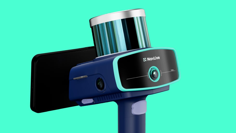
NavLive combines cutting-edge robotics research with real-time spatial intelligence, giving estates teams a handheld tool that captures, processes, and delivers accurate 2D and 3D building data as they move through a space.
Powered by advanced SLAM technology and high-density LiDAR, it processes geometry and imagery directly on-device. As you walk, the system identifies walls, doors, and structural elements with survey-grade accuracy, giving instant visual feedback and live progress tracking on screen.
Behind the scenes, AI algorithms and inertial motion sensors work together to keep every scan aligned and stable, even through tight corridors or complex multi-level buildings. RICS-ready deliverables such as floor plans, elevations, and sections are generated during scanning, eliminating hours of manual post-processing.
Once captured, your data syncs seamlessly to the NavLive Portal, where teams can review, annotate, measure, and export models in open formats like DXF, PDF, E57, or LAS.
The result is a rapid, end-to-end workflow that lets estates teams scan an entire building in minutes, or an entire campus in days, and have accurate, compliant spatial data ready to share straight away.
Why Universities Choose NavLive vs Alternatives

Universities manage some of the most complex and diverse estates in the UK. Heritage buildings beside new labs, teaching spaces alongside high-security research facilities. NavLive was built precisely for that world: fast to deploy, academically rigorous, and ready to scale across entire campuses.
- Born in academia: Developed from Oxford University robotics research, NavLive combines the scientific precision of advanced SLAM technology with a deep understanding of how universities actually operate.
- Handheld & SLAM-powered: No scaffolds, tripods, or external markers. Walk, scan, and capture as you go. NavLive’s handheld design lets estates teams map anywhere, from narrow corridors to basement tunnels, without disrupting teaching or operations.
- Versioned audit trail: Every scan is time-stamped, giving you a complete record of how your buildings evolve. Perfect for compliance with the Building Safety Act and internal audit requirements.
- Open formats & seamless integration: Export to standard data types and plug into your existing BIM, CAFM, or facilities management systems. NavLive doesn’t lock you into a single platform, it enhances the systems you already use.
- Scalable across your estate: Start with one building and expand to the entire campus. Whether you manage a compact city site or a multi-location university estate, NavLive grows with you, keeping every structure accessible, comparable, and up to date.
NavLive gives universities a faster, smarter, and more compliant way to maintain control of their estates, turning static floor plans into living, verifiable digital records.
Final Thoughts
Your campus is living, breathing, and evolving. Your digital record should too. NavLive gives you a robust, auditable, spatial backbone for every building you own and manage.
Learn More About NavLive
To discover how NavLive can be instrumental for scanning universities, book a demo with our team, and we’ll walk you through the scanner in person to show you its capabilities first-hand.
